
The East Coast Trail Guide is a digital trail guide and photo book filled with information about Newfoundland’s amazing East Coast Trail, it’s available on Apple Books.
Inside the guide:
|
Current version is 1.13 (Aug. 2021) |
East Coast Trail
The East Coast Trail is an absolutely unique hiking destination that follows the rugged shoreline of the Atlantic Ocean. Hikers exploring this coastal wilderness trail are rewarded with incredible views of spring icebergs, summer whales, and much more.
If you’re planning on hiking the East Coast Trail you can look forward to breathtaking views, exciting wildlife encounters, hidden coves, secluded beaches and dozens of charming towns that can trace their history back to the early 1600s. There is a lot to see along the trail and no matter if you’re a tourist or a traveller, an occasional hiker or a seasoned backpacker, the East Coast Trail Guide will help you make the most of your time and will get you excited about visiting Newfoundland.
Visitors who are short on time will want to check out the guide’s top 10 chapter, which recommends the hikes that show you the absolute highlights of the East Coast Trail, both near and far from St. John’s.
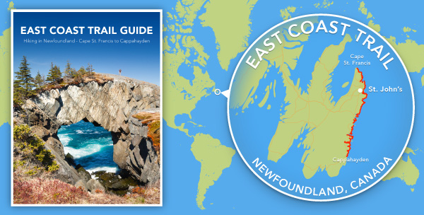
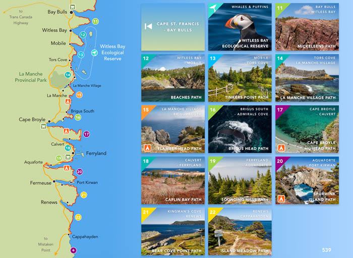
East Coast Trail Guide – Cape St. Francis to Cappahayden
Hikers that want to plan their hikes themselves will want to dive into the trails chapter, which offers 848 pages of detailed trail descriptions and beautifully illustrated trail maps of all the trails that make up the East Coast Trail from Cape St. Francis to Cappahayden:
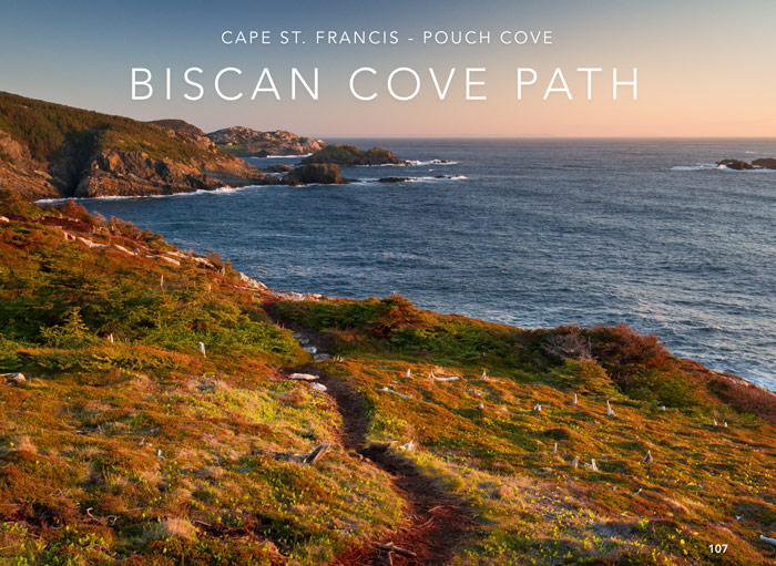
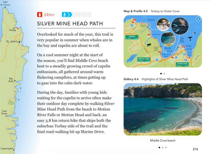
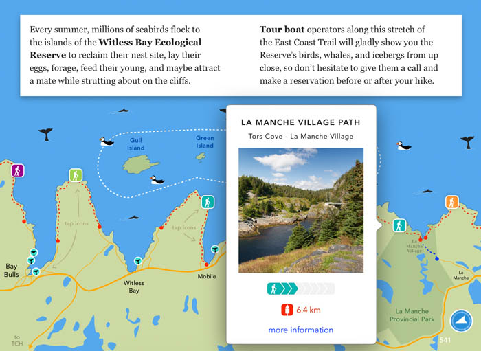
The guide’s most striking feature, however, is its photography.
Every single chapter is filled to the brim with high-quality images: beaches, cliffs, forests, icebergs, berry picking, whales, puffins, moose, capelin; every natural attraction you can find on the East Coast Trail is right here in this beautiful book.
Here’s a quick look inside:


When you’re ready to have a look at the actual East Coast Trail Guide, head over to Apple Books and get the first chapter for free.
Don’t have Apple Books? There’s plenty of information about Hiking the East Coast Trail on this blog too, like basic maps, brief trail descriptions, and trail stories and photos from hikes in every season.

Really great blog! from Nevada USA and doing my masters here in NL, your page has just answered so many questions i had, and so clearly, thanks!!
You’re very welcome Drew, enjoy your time in Newfoundland, I know I did!
Where is the best place we can drive to to see whales that’s not to far from St. John’s please & thank you?
Cape Spear is your best bet for seeing whales close to St. John’s.
I was at Robin hood bay and they all came two where doing jumps and 360 and 180 another couple was just splashing hard over 30 whales most just spray and go up and down — they sound like dogs barking the whale snorts on some —
You finally made it! Wish I could get this on my Samsung =(
I wish that too newfoundlandfox, I hope Apple will release the iBooks app on Android so that more hikers will be able to get the guide.
Hello Sander,
We really love your blog, the content is very detailed and informative, pictures are breathtaking, which all convince us more to hike ECT. We would love to have the app, however, all mobile systems we are using are android. 😦
We plan to hike ECT in this August. We did west coast trail on Vancouver Island in 2014 for 6 days, which we felt comfortable. For ECT, we plan to start at Cape St. Francis, hike to St John’s for 4 days, camp 3 nights.
Do you think this sounds reasonable? and do we have to carry enough food for 4 days?
Really appreciate your help
Ming
Hello Ming,
thank you for your kind words about my blog and pictures, I’m glad they got you excited for the East Coast Trail!
The hike you are planning is about ~65km including the distance between trails, so you’d be taking on ~17km every day, which sounds reasonable to me if you’re fit enough to do this. Along the way, both Pouch Cove and Torbay have convenience stores where you could theoretically replenish your food, but of course you’d have to leave the trail and find these stores first, so yes I would advise bringing everything you need along with you.
As for directions and further preparation, have you looked into getting ECTA’s paper trail maps? They sell them online and in town, I really recommend you get them and study them before you set out on your hike, they’ll get you off to a good start 🙂
Have fun on your hike, August is a beautiful time on the East Coast Trail!
Sander
Hello Sander,
Thank you so much for helpful answers. I haven’t bought the map yet. Do you have any other version of your digital map that I can buy?
Thank you again
Ming
Hi Ming,
I’m afraid my maps are only available inside the East Coast Trail Guide, but ECTA’s maps are really nice too, you can even just buy the bundles for the trails you need.
Happy trails,
Sander
Does anyone know of any areas around Bellvue that you can pick blueberries. I am getting excited about picking them and I can’t control myself. My husband and kids tell me I get blueberry fever! Lols.
My husband had to buy another deep freeze just for blueberries, and believe me, it was filled and I even had to bring a nice few gallons to my in-laws because I never had anymore room.
Yes that does sound like blueberry fever!
I’m not familiar with the area around Bellevue, I’ve only been there a few times and that was to visit the beach :-). Maybe you could ask some of the locals there, I’m sure there must be quite a few good picking spots nearby…
Hey everyone,
I would like to pick up some berries today. Where should I go? I am in St. John s.
Thank you!
If you don’t mind a little climbing, the South Side Hills on Deadmans Bay Path are a great place to pick blueberries. From the trailhead near Fort Amherst, follow the red trail (see map) up the hill, then make a right turn onto the blue trail, which leads to great views and a ton of blueberries.
Thank you!
I am planning a few days hiking the East Coast Trail this summer and stumbled across your book. The pictures are amazing and the trail maps and descriptions perfect! After looking through it I am ever more excited for hiking the trail this summer!
Thanks so much Angie, I’m glad to hear the guide made you excited about hiking the trail, that’s exactly what it’s for! 🙂
Hi there, your guide looks awesome – lots of great details! I plan on hiking a few parts of the trail in late April/early May, what do you think I can expect in terms of weather? That’s the only time that I can go, but I want to be sure that I can get out to the trails/paths/etc, and not face too much inclement weather. Do you think this will be the case? Thank you 🙂
Hi Janelle,
Thanks for reading my guide, glad you like it! Late April to early May is a great time to hike the East Coast Trail, most of the snow will have melted by that time, save for some places deep in the forest where the sun’s warmth hasn’t been able to reach yet. This year looks great for icebergs, so you’ve got that to look forward to, and in my personal experience the weather shouldn’t be all that bad either. Just keep an eye on the most recent forecast when you set out, and bundle up nice and warm 🙂
Enjoy your hike and stay safe!
Hi there. Your book and the East Coast trail look fantastic! I will be hiking alone, hoping to hike and camp from Witless or Bay Bulls to St. John’s. Is there a good place to park for the few days that I’m hiking? I am hoping to park in St. John’s, (somehow get down the highway to start my hike) then end up back with my car in St. John’s.
Is this feasible?
Thanks, Ted
Hi Ted, thanks for you comment, I will send you an email with some suggestions shortly.
I’ve come across quite a few sites on the East Coast Trail, and yours is the best I’ve seen in terms of photos and user friendly information. So thanks! I’m planning a trip of The Trail in mid-September, heading south from St. John’s and going as far as I can in 5 days or so. I don’t plan on renting a car, and prefer not to do an out-and-back. Any tips on how to get back to St. Johns from locations south on the trail? Shuttles? Taxis? Thumb it? Much appreciated.
Stefan
Thanks Stefan, glad you find the site useful 🙂
As for getting back to St. John’s after your 5-day hike, I would say a taxi is the quickest and easiest way. Randy Best has an excellent website with lots of information for more experienced hikers like yourself, check out his notes on transportation here.
Agreed on Randy Best’s guide! When I walked the ECT from St. Johns to Ferry and, I noticed that at most of the trailheads there were signs with taxi numbers that you could call for pickup.
Thanks Judith, good to know that most of the trailheads have taxi information now 🙂 Randy’s thru-hiking website has been offline for a while now, hope it comes back up at some point.
Thank you so much for your blog! I am thinking of doing a 5 day hike at the end of August. I was hoping to start at one point and end up near St. John’s. Is that feasible? And if so, where would you recommend starting from in terms of scenic hiking? Thanks!
Hi Teaghan,
Five days on the East Coast Trail sounds like a week well-spent!
Where to start your hike depends on how much you want to hike per day. If you’re comfortable hiking about 18 km a day, I recommend you start your hike in Tors Cove and hike all the way up north to Fort Amherst in St. John’s. This way, you’ll start with 2 easy trails (Tinkers Point Path + Beaches Path) and increase the difficulty from that point on, eventually ending on a high note with a beautiful view of the Narrows before arriving at Fort Amherst.
The total distance of that 5-day hike is about 90 km and includes roughly 16 km of road walking through communities between individual trails. If for some reason you don’t make it all the way to Fort Amherst, you could always stop earlier like at Petty Harbour or Cape Spear for example, and take a taxi back to town from there.
If you’re up for more than 18 km a day, I suggest starting from Brigus South instead, making for a total distance of about 110 km which includes about 22 km of road walking between trails. This hike adds up to an average of 22 km a day and it adds a beautiful forest trail to the start of your hike (Flamber Head Path).
Both options are good hikes, both include the super-scenic Spout Path and Motion Path, so choosing between them merely depends on your preferred pace and how much time you want to spend hiking vs resting. Personally I always go with a shorter distance a day because it gives me more time to take in the scenery and watch the wildlife.
Whichever way you go, have fun planning, if you have any more questions let me know on the contact page so I can try to help you further. Happy trails!
Sander
Hi Sander – My husband and 3 other couples are planning a trip to the ECT Sept 2018. Wondering if you could advise on good trails, connected by BnB’s. I hear the BnB’s transport packs etc between trails? We are all pretty fit, & active people. Prefer moderate to difficult level.
Hello Evelyn,
Yes there are several good accommodations along the East Coast Trail that offer ‘hiker specials’ or ‘hiking packages’. This can mean anything from offering a guided hike with the room, or the luggage transfer between B&Bs you asked about, or driving you to and from trailheads, or even setting up a whole hiking itinerary with you, maybe even adding whale watching trips and such.
I suggest you check out these websites: Wild Roses, Harbour House, Bread and Cheese Inn, and Brown Rabbit Cabins. They all offer some sort of package for hikers, so maybe contact a few to see what your options are when traveling in a group of 8 hikers.
As for moderate to difficult trail suggestions, I recommend the following trails (north to south): Stiles Cove Path, Deadmans Bay Path, Motion Path, Spout Path, Flamber Head Path, Brigus Head Path and Spurwink Island Path. Now these trails are not all easily connected by B&Bs, but I’m sure you can arrange with your hosts to drop you off and pick you up at the end of your hike each day.
Hope this helps 🙂
Sander
are there designated places in the towns along the trail to store food and or fuel to get while walking
Hi Kathleen, there are no designated places to store food in towns or along the trail. Many (but not all) towns do have convenience stores or supermarkets to get supplies. Randy Best has a website with great information for thru-hikers, you may want to check it out here.
Hi, your guide looks fabulous, but I would like to download it onto my android phone. Is there any way to purchase it through google play?
Hi Judy, unfortunately the East Coast Trail Guide is not available on Android phones and tablets as iBooks is not available those devices. I hope you’ll still find the blog useful though 🙂
Thanks for getting back to me so quickly! Yes the blog is great, and I will certainly keep reading! I’m planning on spending 10 somewhat leisurely ( stopping to see wildlife and scenery instead of barging through and staring at my boots) days on the trail sb from St. John’s to wherever I end up. It looks like I’ll need to wing it a bit as far as arranging the taxi at the end of the 10 days since I won’t know exactly where I’ll end up.
That’s the way to do it for sure, wing it and enjoy your time on the trail. Without a fixed finish line you’ll be able to make the absolute most of any trail experience you’re going to have. Have fun and stay safe 🙂
Hi was wondering if the trail book is available for purchase in paper copy?
Hi Kimberly,
Unfortunately a paper version of the East Coast Trail Guide is not available. At over a thousand pages thick it would no longer be as practical, pocketable and lightweight as it is now. Also, all of the interactive elements would be lost.
Thank you for your interest though! 🙂
Cheers,
Sander
Hey! I am planning to hike and camp from La Manche to Black Head sometimes between sept 20th and 27th. Is this a good idea? How is the weather and how are the trails at this time of the year? Anything specific I should know and prepare for? Also, any tips to how to get to La Manche from St John’s? As I’ll be travelling from Montréal, I won’t have my car. I heard of taxis but I was wondering if you had other tips.
Thanks for your help! Very excited for this adventure!
Hi Claudel! I think that you would have a better time traveling north- south from dead man’s path to La Manche.
This way,
1) you are starting in St John’s- no taxi needed.
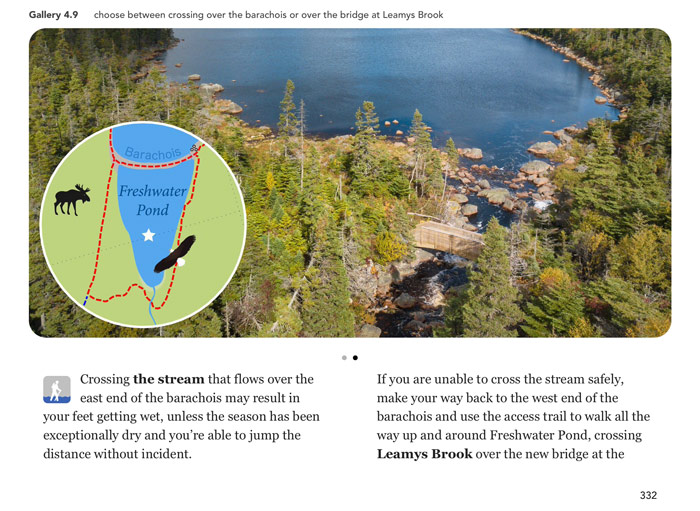
2) You will get the first 5 or so difficult kilometers of the Spout path done first- after the Spout and the climb up to the camp site, the trail is much easier.
3) you will get the road walk portion of the LaManche trail done first, so that you can enjoy the suspension bridge and ruins more.
When you get to LaManche there is an access trail ( I didn’t take it, as I hiked to Ferryland), that can take you to the main highway easily.
4) you can call South Shore taxi ( they have signs up at almost every trail head) to get you back to St. John’s.
Hi Claudel, great tips from Judy above, thanks Judy!
Your chosen dates are great, it’s a fantastic time of year to hike the East Coast Trail. Trails are typically in good shape at the very end of summer, and the weather forecast looks to be good too right now, but keep in mind it’s highly changeable. A full week of pleasant weather would not surprise me, but a week of rain and fog can sneak up on you just as easily. I agree with Judy that taxi is the way to go, but you could try hitchhiking too. Stay safe and have fun 🙂
Love this blog as a reference when planning ECT trips! Is there any way to get the guidebook for non apple users? Cheers
Hi Dylan, the East Coast Trail Guide is only available on Apple Books. Glad to hear you enjoy my blog for planning your East Coast Trail hikes, happy hiking 🙂
Nice blog…quite helpful…Thanks for setting this up. Question: What might be the main differences (if any) between the ECT trail north of St. John’s and ECT trail south of St. John’s? How might one decide which way to go from St. John’s? Cheers!
Hi Stephen,
One big difference between the two directions is that the trails north of St. John’s are more recent additions to the East Coast Trail, in fact, some of them are still being developed (along Conception Bay). From a hiker’s perspective, a more important distinction is that many of the newer trails have a more challenging elevation profile than the older trails down south.
If you feel like you must choose between north or south of St. John’s, most hikers usually go for the 4 classic trails south of St. John’s, hiking either from Fort Amherst down to Bay Bulls or the other way around. That’s Deadmans Bay Path, Cape Spear Path, Motion Path, and Spout Path. Hiked back to back, these 4 trails offer a little bit of everything, including some amazingly scenic views.
Most of the trails further south (Bay Bulls to Cappahayden) offer great hiking too, and one of the nicest things about them is that they’re a lot less hiked the further you travel south. With a few exceptions, the elevation profiles there are a lot less taxing too.
Hopes this helps 🙂
Just downloaded your book and am keen to dig in. We are setting aside 10-14 days to consecutively hike point to point and think that we could manage 20+kms per day as we are fit experienced hikers. Would you have a recommendation for us on where to start and finish? Also, how many days to hike the entire trail in your view for someone doing 20kms per day…is it as simple as 310 divided by 20 or is it more complex. thanks bob
Hi Bob, thanks for getting the East Coast Trail Guide, I’m sure it will get you even more excited for your trip!
From start to finish, the East Coast Trail is currently about 337 km long, including road-walking distance through towns between the different legs of the trail. If you want to see all of it, my suggestion is to start at Topsail Beach, finish in Cappahayden, then get yourself picked up at the finish line when you’re done.
If you want to take a little distance off your total hiking trip, my suggestion is to skip both the first and the last path of the East Coast Trail. That means starting in Portugal Cove, and finishing the hike in Renews, for a total hiking distance of about 310 km.
Hiking about 20 km a day seems like a fair estimate for fit hikers. If you’re very fit you could probably do a little more but limiting yourself to 20 km a day gives you more time to hike leisurely and encounter some wildlife, enjoy the viewpoints, and rest at your campsite at the end and start of your day.
As for how many days it would take you, yes, if you want to hike 310 or 337 km you can simply divide by 20 and figure out how many days that will take you. Of course you will not be able to find a suitable camping place at neat 20 km intervals, but since you’re hiking for many consecutive days, the shorter and longer hiking days should still just about average out to 20 km.
Have fun and stay safe 🙂
thanks. Based upon now starting to go through your excellent book I am thinking Cape St. Francis to Cappahayden…and going N to S vs S to N? Thoughts?
This is last minutes planning as we are looking to start next week!
Yes, that’s an excellent way to do it, but if you’re driving to the start of your hike, keep in mind the road to Cape St. Francis may not be suitable for all vehicles. If a taxi won’t take you there, get yourself dropped off at the end of Pouch Cove instead and then walk Route 20 to Cape St. Francis, before starting your East Coast Trail hike at the Cape St. Francis trailhead.
We will be needing to take a taxi, so thanks for that tip. Any taxi company that you would recommend?
I know the taxi company names but have limited experience with them. If you’re arriving in St. John’s you’ll find City Wide taxis waiting at the airport, and downtown you’ll see Jiffy Cabs and Budgens.
More important than finding a taxi is finding a driver who knows the East Coast Trail trailheads. If possible, call ahead to see who can drop you off in Pouch Cove, and most importantly, who can pick you up all the way from Cappahayden.